August 17, 2006 – The Day of Tungurahua
Today’s plan was to head west from Shell Mera after breakfast, passing through Banos and Ambato on the way back to Quito. After two days of driving over long segments of poor quality roadways, we were looking forward to driving back to Quito on nice, paved roads. I woke up early, and recalling that I needed to plug in my camcorder and battery charger, I went to plug them in and they didn’t light up, so I tried another plug, with similar results. I then tried turning on the room light, but no luck. Well, the power is out, but I suppose that happens on occasion around here, so no big deal as I’ve got other batteries charged that I can use if need be. I go back to sleep for awhile. I and others wake up a bit later and the power still wasn’t on, but we made the best of it, having porridge and rolls for breakfast.
Glenda, one of the folks that runs the place came into the building and told us that she had heard at the corner market that the Tungurahua volcano had erupted last night and that the road to the west through Banos was reportedly closed. Tungurahua was also responsible for knocking the power out, as this region relies on a major hydroelectric plant on the Rio Pastaza, not far from Tungarahua (we later learned that power was knocked out in all or part of Ecuador’s four jungle provinces due to transmission lines getting knocked out. Sounds like they need some transmission line redundancy!). We also hear rumors of mudslides in the Banos area and evacuations. This all makes us quite nervous, as we are scheduled to fly out of Quito in two days and our main route for getting back to Quito is blocked for who knows how long. Basically our options are to wait to see if the road through Banos opens back up, a dubious option given our flight schedule, or to retrace our steps the last two days back through Puyo and Tena. This option hardly thrills us, as we remember all too well the many rough sections of road we passed over, never thinking we would be contemplating a return trip. But a return trip it must be, as the consensus is that there’s no other good way to get back to Quito on a timely basis. Will the little Chevy Cista, with it’s lack of clearance, hold up after the beating it took the first time? Well, today we’ll find out. It’s rather cloudy out, including to the west, so we don’t have any view of “Mama” Tungurahua and the trouble she is stirring up.
At least we’re getting a relatively early jump on things as we’re leaving Shell Mera by 8:30 a.m. We bid farewell to the folks at Shell Mera, including a German family who are also heading back to Quito today and will traverse the same route as us (though they’ve got an SUV that can handle the route better than our Cista). We head east a few miles, hit Puyo and then we’re heading north to Tena. We note the different road conditions as we remember them from our drive in the other direction.

Fun road conditions
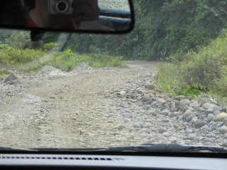
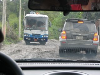
One event I didn’t mention yesterday, but I will now, is our run-in with a grader on the road between Tena and Puyo. The non-paved roads in the area we were passing through weren’t good, but we were doing ok, as we headed south yesterday. Then we come upon an area where something has pulled boulders and rocks of all sizes out of the ditch and into the middle of the road, forming a bit of a barrier in the middle, as well as a scattering of different sized rocks scattered along the rest of the road. Why someone would do this puzzles us, as these rocks are not what you want to have in the road to drive over! Part of the problem is deciding which side of the middle barrier to go down, and wondering which way the on-coming traffic will choose. We start going down one side and then come across the transgressor who is creating such road havoc. It’s a grader and he’s running down one side of the road, using his blade to pull the rocks back into the roadway. We look at each other, wondering what the guy running the grader is thinking. Our lane is now narrowing down too much to continue, so we hop out of the car and John, Walter, and I move enough rocks and dirt from the middle barrier to allow our car to get back over to the other side. We continue on, but several times run across a bus or big truck coming the other way, and it was a very tight squeeze for both of us to fit down one side of the road and pass each other. Well, anyway, today as we’re heading north from Puyo, we run across the same telltale signs of the grader run amok, as large rocks run along the middle of the road with various rocks scattered elsewhere on the roadway. We reach a point where there is no lane that we can drive down that is wide enough to not go over sizable rocks that would do unpleasant things to the underside of our Chevy. So for one segment of road John and I hop out of the car and walk in front, kicking and throwing rocks out of the way to make a way for Walter to drive the car forward. In Ecuador you just never know what you’ll be doing from one day to the next. After a little while we’re in the clear, past the segment of road where the grader continues to make life difficult for people who actually have to drive on the road.

More fun road conditions

The Rio Napo, at Puerto Napo
Another thing we did a few times was when there was a particularly bad rut the car had to go over, John and I both got out and walked, lightening the load for the car so it would have a little bit more clearance. This seemed to help a bit. We’re still having a few scrapes on the bottom of the car, but not as many as the first time we passed over these roads. We reach Tena a bit before noon and decide to push ahead rather than stopping to eat or rest. The road north from Tena is pretty good until past Archidona, when we hit the long stretch of bad road that lasts most of the way to Cosanga. One strange thing on this stretch of road is that for several short stretches there are segments of new road, but on other side of the good segment are long segments are quite rough road. We ponder why they would build a short segment of good road while not connecting it to more good road in either direction? Well, hey, I’m just an American visiting the beatiful country of Ecuador, so I won’t worry about it too much. The weather has gradually cleared up a bit and we gradually plug our way along this long stretch of mostly bad roads. Walter seems to be doing better at avoiding the bad scrapes on the bottom of the car, assisted at least to some extent by our spotting of especially bad bumps. It sure seems we’ve spent a lot of this trip driving from one place to another, especially given that Ecuador isn’t that big of a country and we’ve mostly stayed in the central part of the country.

These guys don´t seem to mind the road conditions!

What could be around the corner? More bad road, that´s what.
As we climb in elevation, it starts drizzling a bit, but not enough to cause any problems. Eventually we emerge 7.7 kilometers from Cosanga to the civilized world of well-paved roads. Woohoo! We pass through Cosanga and then stop in Baeza for a late lunch at a little cafe there. Our lunch includes some rice and lentils, which Mom says is very fitting, as Grandpa and Grandma Cedar would have rice and lentils sometimes as they traversed this area too and from Quito on mules or horses. With this sustenance we now push on toward Quito, passing through Papallacta again. Puzzlingly, the roads through and near Papallacta are not paved and are the worst this side of Cosanga.

Bad roads near Papallacta

Several water falls near Papallacta

The river near Papallacta ( I forget the name right now)
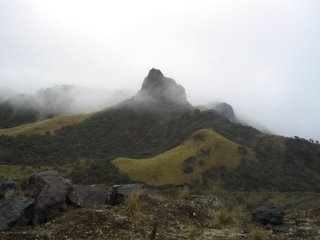
The Andes Mountains are partially masked by intermittent clouds and fog, a view Mom says was very common in the days when they lived in Ecuador.
After passing through Papallacta, we head into the paramo, the high, mostly treeless region of Ecuador. It’s hear we again hit the high point of the road before starting our journey down to Quito.

The paramo, high in the Andes Mountains. Kinda reminds me of Scotland!
And more paramo
The remainder of the trip is relatively uneventful, and we arrive safely back at Hotel Los Alpes in Quito, anxious to find out what’s happening with Tungurahua and let folks back home know that we’re ok. The whole trip from Shell Mera to Quito took a bit over seven hours of driving, plus stops, but as we find out the extent of Tungurahua’s effects, we’re glad we chose the route we did.
We bid farewell to Walter and settle into the hotel for the evening, having dinner after resting a little while. Tomorrow will be our last day in Ecuador, and we plan to spend it doing a few things around Quito. We read and watch the news coverage of Tungurahua’s destruction, with early reports of one death, three villages destroyed, a number of other towns damaged, major evacuations, significant property damage, etc. If the eruption had taken place, oh, six or nine hours later, we might have found ourselves in a very challenging situation, as we’d be on the road through Banos to Ambato that was heavily impacted by the volcano. Someone at our hotel mentions that he heard the Quito airport is closed due to ash, but we haven’t noticed ash in Quito and news reports we see only reference airport closures to the south, in cities like Ambato, Riobamba, and Guayaquil. But we’ll have to keep an eye on things the next day or so, as who knows what might happen next in the unpredictable country of Ecuador.
Glenda, one of the folks that runs the place came into the building and told us that she had heard at the corner market that the Tungurahua volcano had erupted last night and that the road to the west through Banos was reportedly closed. Tungurahua was also responsible for knocking the power out, as this region relies on a major hydroelectric plant on the Rio Pastaza, not far from Tungarahua (we later learned that power was knocked out in all or part of Ecuador’s four jungle provinces due to transmission lines getting knocked out. Sounds like they need some transmission line redundancy!). We also hear rumors of mudslides in the Banos area and evacuations. This all makes us quite nervous, as we are scheduled to fly out of Quito in two days and our main route for getting back to Quito is blocked for who knows how long. Basically our options are to wait to see if the road through Banos opens back up, a dubious option given our flight schedule, or to retrace our steps the last two days back through Puyo and Tena. This option hardly thrills us, as we remember all too well the many rough sections of road we passed over, never thinking we would be contemplating a return trip. But a return trip it must be, as the consensus is that there’s no other good way to get back to Quito on a timely basis. Will the little Chevy Cista, with it’s lack of clearance, hold up after the beating it took the first time? Well, today we’ll find out. It’s rather cloudy out, including to the west, so we don’t have any view of “Mama” Tungurahua and the trouble she is stirring up.
At least we’re getting a relatively early jump on things as we’re leaving Shell Mera by 8:30 a.m. We bid farewell to the folks at Shell Mera, including a German family who are also heading back to Quito today and will traverse the same route as us (though they’ve got an SUV that can handle the route better than our Cista). We head east a few miles, hit Puyo and then we’re heading north to Tena. We note the different road conditions as we remember them from our drive in the other direction.
Fun road conditions
One event I didn’t mention yesterday, but I will now, is our run-in with a grader on the road between Tena and Puyo. The non-paved roads in the area we were passing through weren’t good, but we were doing ok, as we headed south yesterday. Then we come upon an area where something has pulled boulders and rocks of all sizes out of the ditch and into the middle of the road, forming a bit of a barrier in the middle, as well as a scattering of different sized rocks scattered along the rest of the road. Why someone would do this puzzles us, as these rocks are not what you want to have in the road to drive over! Part of the problem is deciding which side of the middle barrier to go down, and wondering which way the on-coming traffic will choose. We start going down one side and then come across the transgressor who is creating such road havoc. It’s a grader and he’s running down one side of the road, using his blade to pull the rocks back into the roadway. We look at each other, wondering what the guy running the grader is thinking. Our lane is now narrowing down too much to continue, so we hop out of the car and John, Walter, and I move enough rocks and dirt from the middle barrier to allow our car to get back over to the other side. We continue on, but several times run across a bus or big truck coming the other way, and it was a very tight squeeze for both of us to fit down one side of the road and pass each other. Well, anyway, today as we’re heading north from Puyo, we run across the same telltale signs of the grader run amok, as large rocks run along the middle of the road with various rocks scattered elsewhere on the roadway. We reach a point where there is no lane that we can drive down that is wide enough to not go over sizable rocks that would do unpleasant things to the underside of our Chevy. So for one segment of road John and I hop out of the car and walk in front, kicking and throwing rocks out of the way to make a way for Walter to drive the car forward. In Ecuador you just never know what you’ll be doing from one day to the next. After a little while we’re in the clear, past the segment of road where the grader continues to make life difficult for people who actually have to drive on the road.

More fun road conditions

The Rio Napo, at Puerto Napo
Another thing we did a few times was when there was a particularly bad rut the car had to go over, John and I both got out and walked, lightening the load for the car so it would have a little bit more clearance. This seemed to help a bit. We’re still having a few scrapes on the bottom of the car, but not as many as the first time we passed over these roads. We reach Tena a bit before noon and decide to push ahead rather than stopping to eat or rest. The road north from Tena is pretty good until past Archidona, when we hit the long stretch of bad road that lasts most of the way to Cosanga. One strange thing on this stretch of road is that for several short stretches there are segments of new road, but on other side of the good segment are long segments are quite rough road. We ponder why they would build a short segment of good road while not connecting it to more good road in either direction? Well, hey, I’m just an American visiting the beatiful country of Ecuador, so I won’t worry about it too much. The weather has gradually cleared up a bit and we gradually plug our way along this long stretch of mostly bad roads. Walter seems to be doing better at avoiding the bad scrapes on the bottom of the car, assisted at least to some extent by our spotting of especially bad bumps. It sure seems we’ve spent a lot of this trip driving from one place to another, especially given that Ecuador isn’t that big of a country and we’ve mostly stayed in the central part of the country.

These guys don´t seem to mind the road conditions!

What could be around the corner? More bad road, that´s what.
As we climb in elevation, it starts drizzling a bit, but not enough to cause any problems. Eventually we emerge 7.7 kilometers from Cosanga to the civilized world of well-paved roads. Woohoo! We pass through Cosanga and then stop in Baeza for a late lunch at a little cafe there. Our lunch includes some rice and lentils, which Mom says is very fitting, as Grandpa and Grandma Cedar would have rice and lentils sometimes as they traversed this area too and from Quito on mules or horses. With this sustenance we now push on toward Quito, passing through Papallacta again. Puzzlingly, the roads through and near Papallacta are not paved and are the worst this side of Cosanga.
Bad roads near Papallacta

Several water falls near Papallacta

The river near Papallacta ( I forget the name right now)
The Andes Mountains are partially masked by intermittent clouds and fog, a view Mom says was very common in the days when they lived in Ecuador.
After passing through Papallacta, we head into the paramo, the high, mostly treeless region of Ecuador. It’s hear we again hit the high point of the road before starting our journey down to Quito.

The paramo, high in the Andes Mountains. Kinda reminds me of Scotland!

And more paramo
The remainder of the trip is relatively uneventful, and we arrive safely back at Hotel Los Alpes in Quito, anxious to find out what’s happening with Tungurahua and let folks back home know that we’re ok. The whole trip from Shell Mera to Quito took a bit over seven hours of driving, plus stops, but as we find out the extent of Tungurahua’s effects, we’re glad we chose the route we did.
We bid farewell to Walter and settle into the hotel for the evening, having dinner after resting a little while. Tomorrow will be our last day in Ecuador, and we plan to spend it doing a few things around Quito. We read and watch the news coverage of Tungurahua’s destruction, with early reports of one death, three villages destroyed, a number of other towns damaged, major evacuations, significant property damage, etc. If the eruption had taken place, oh, six or nine hours later, we might have found ourselves in a very challenging situation, as we’d be on the road through Banos to Ambato that was heavily impacted by the volcano. Someone at our hotel mentions that he heard the Quito airport is closed due to ash, but we haven’t noticed ash in Quito and news reports we see only reference airport closures to the south, in cities like Ambato, Riobamba, and Guayaquil. But we’ll have to keep an eye on things the next day or so, as who knows what might happen next in the unpredictable country of Ecuador.
posted by Bob at 8:01 PM
![]()


1 Comments:
Little did I realize when I emailed you that story a few weeks back. I checked CNN and they were indicating this was a pretty big eruption.
Post a Comment
<< Home